The first icebergs we saw on the cruise off NE Canada coast were in the Labrador Sea.
Our itinerary was to cruise the northeast coast of Akpatok Island, one of the uninhabited Canadian Arctic islands in the Qikiqtaaluk Region of Nunavut. Nunavut is the largest and northernmost territory of Canada, forming most of the Canadian Arctic Archipelago.
However we didn't get the permit to go to Akpatok. Apparently it is the hunting season for the Inuit to catch whales. Akpatok is the largest island in Ungava Bay on the northern coast of Quebec. The island is named for the Akpat, the thick-billed murre, or Brünnich's guillemot, part of the auk family. The birds live on ledges along the limestone cliffs surrounding the island. Akpatok Island is predominantly limestone, ringed with steep cliffs that rise 150 - 250 m above sea level. The cliffs are broken in many places by deep ravines allowing access to the flat plateau 23 km wide and 45 km long. The island is a Canadian Important Bird Area. The Thick-billed murre, photo from Wikipedia, by Verena Gill -
We did see some of the murres as we were sailing the previous evening. They were in small groups and all dived together and disappeared -
We started the day scenic cruising Nunavut.
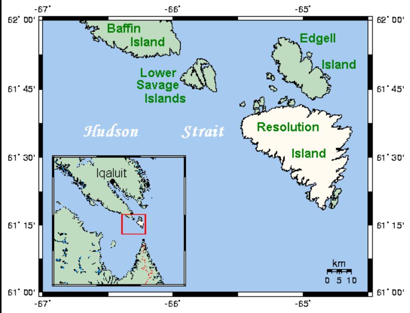
Atapak Island is the small island shown in the box (SW corner of red square).
Got up to thick fog. We were off the south end of Resolution Island, Nunavet, but of course there was nothing to see. Resolution is a Canadian Arctic island south of Baffin Island, separated from it by the Lower Savage Islands. It is located in Davis Strait and is uninhabited. English explorer Martin Frobisher landed on the island on July 28, 1576, while on a voyage to discover the fabled Northwest Passage. However it appears to have been named Resolution in 1612 by Sir Thomas Button, after his own ship, the Resolution. It was badly contaminated by PCBs from an old US military base.
Resolution Island -
Thankfully it brightened up and the fog lifted so at least we could see the island. The redpoll stowaway was more alert as well -
However as soon as we got to the north end of Resolution, the fog returned. We sailed between the north end of Resolution and south of the Lower Savage Islands but it was still foggy. The Lower Savage Islands are an uninhabited offshore island group of Baffin Island, located in the Arctic Archipelago in the territory of Nunavut. The islands lie in the Gabriel Strait, an arm of Davis Strait, northwest of Resolution Island, and west of Edgell Island.
We went up the east side of the Lower Savage islands then headed west along the top. We were quite close and “hoped” to see polar bears but the fog was back and we could hardly see the land. Such a pity.
We got midway along the western island then it was announced that was the end of the scenic cruising as there was no view, and we would put on speed and head for Nuuk in Greenland.
At least we saw some icebergs on the way. This one had a cave, also a waterfall at one end. We went around it, it was an estimated 40 x 150 m. -
Some different icebergs -
This one had a cave almost at water level -
This was one of the prettiest, with a long smooth whale-like front with a big tall crown behind. The bridge people estimated it to be 70 m high. Note how the shape changes as we went around it -
Our next port of call was Nuuk in Greenland.


%20murres.jpg)

%20Resolution%20Island.jpg)
%20Resolution.jpg)
%20Resolution.jpg)
%20redpoll.jpg)
%20Lower%20Savage.jpg)
%20.jpg)
%20.jpg)
%20.jpg)
.jpg)
%200240803.jpg)
.jpg)
%2020240803.jpg)
%2020240803.jpg)
%20.jpg)
%20.jpg)
%20.jpg)


%20iceberg.jpg)
%2020240801.jpg)
%2020240801.jpg)
.jpg)
.jpg)
.jpg)
.jpg)
%20gulls.jpg)
.jpg)
%2020240801.jpg)
.jpg)
%20join.jpg)
.jpg)
.jpg)
%2020240802.jpg)
%2020240802.jpg)
%20.jpg)
%2020240802.jpg)
.jpg)
%20just%20calved.jpg)
%20seal%20Z.jpg)
%2020240802.jpg)
.jpg)
.jpg)
%20gulls.jpg)
%20gulls.jpg)
%20fog.jpg)


.jpg)
%2020240731.jpg)
%2020240731.jpg)
%2020240731.jpg)
%2020240731.jpg)
%2020240731.jpg)
%2020240731.jpg)
.jpg)
%2020240731.jpg)
%2020240731.jpg)
.jpg)
%2020240731.jpg)
.jpg)
%20eider.jpg)
.jpg)
%200240731.jpg)
.jpg)
%2020240731%20join.jpg)
%20join.jpg)
%2020240731.jpg)
.jpg)
.jpg)
%2020240731%20snapdragon%20join.jpg)
.jpg)