Enjoy!!!

Enjoy!!!
Showing posts with label Canary Islands. Show all posts

Monday, April 4, 2022

César Manrique sculpture, Arrecife, Tenerife, Canary Islands

In 2014 I visited  the Cesar Manrique Foundation on Lanzarote on the Canary Islands. Cesar Manrique was a famous Spanish artist, sculptor and architect, born in 1919 on Lanzarote. There are many tributes to him around the island. He died in 1992.

When I was back in Arrecife in March 2022, I saw a new sculpture along the waterfront, "The Look of Cesar". It is located on the Avenida Marítima de Arrecife. It was installed as a tribute to the artist. The sculptor was Manolo González.

César's Look, or César's Gaze, shows him sitting in the center of an eye-shaped window, a metaphor for his illustrious gaze, his visionary spirit and his innovative character. Cesar had a great respect for nature and the work is a recognition and gratitude of the people of Lanzarote.

It was only installed on the 18th February 2022, so I was lucky to see it a month later. Read more here.

It was hard to get a good photo as the sun was so bright, and also people kept getting in the way, posing with Cesar.


Sunday, April 3, 2022

Teide volcano, Tenerife, Canary Islands

 The Mount Teide National Park on Tenerife is an area of geological formations - volcanoes, craters, vents, lava fields and interesting rock formations. The national park is dominated by Mount Teide. Its summit is the highest point in Spain, which surprised me. It is at 3715 m and is also the highest point above sea level in the islands of the Atlantic. It last erupted in 1909. 

The week before I visited, Storm Celia brought snow to Gran Canaria. There was certainly snow on Mount Teide and the roads through the park.

First view of Mount Teide -


The Canary Island Pine forests -


The Teide Observatory -


We continued along and our next stop was at Portillo Alto, where we had a different view of the volcano, 2nd photo shows a crater the other side of the road -


We continued on to the Canadas caldera. On the way we passed fields of pumice with lumps of glassy black obsidian, and lava channels -


When we reached the main viewing area, the road and parking areas were absolutely packed with vehicles and people.


The lava fields of Las Canadas caldera. The lava is the 'aa' type, meaning it is rough and knobbly and hard to walk on.


We were so lucky with the weather. In fact we were above the clouds, but had to go through them to go back down to Santa Cruz


Saturday, April 2, 2022

La Palma volcanoes, Canary Islands

The Canary Islands are part of Spain and lie off the coast of northwestern Africa. They are volcanic in origin. There are 8 main islands. La Palma is one of the smallest of the Canary islands and is very mountainous. It is the most north-westerly island of the Canaries and is heart shaped.


The capital Santa Cruz de La Palma is nestled at the foot of steep hills, has cobbles and is famous for the houses in Portuguese style with wooden balconies.

The island was in the news often from September to December 2021 due to the volcanic eruption. The eruption wasn't actually from a volcano, but from the Cumbre Vieja volcanic ridge, in the southern half of the island. It lasted from 19 September to 13 December 2021 and was the first volcanic eruption on the island since the eruption of Teneguía in 1971. At 85 days, it is the longest known eruption of a volcano on La Palma.

As already mentioned, La Palma is shaped like a heart. And within this is another heart shape, the spectacular volcanic crater, Caldera de Taburiente in the north of the island. The caldera area is within a national park. I went on a tour to the park. Firstly we stopped at the Caldera de Taburiente visitor centre, mainly to see the model of the island which clearly shows the heart shapes. 


The weather was really awful, with rain and low cloud. We didn't expect to have any view from the top, but went up anyway, along very narrow and steep roads. The national park is full of Canary Island pine trees. These have been found to be fire resistant and can survive forest fires as the bark protects the inner tree.


We reached the top of the road where there should be great views of the Caldera de Taburiente, but we were right up in the clouds and it was raining so we could see nothing. There was no point in getting out of the coach to walk to the viewpoint.

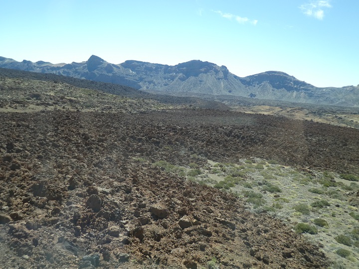
So although we missed the main attraction of the tour, to fill time, our guide arranged for us to see last year's volcano. We headed for the town of Tajuya and stopped at a viewpoint outside the church. 


In front of us we could see the lava that covered houses and an industrial site. The eruption came out of the ground higher up. We couldn’t see it, but we could see the steam issuing from the lava field. The road to other villages has been buried and won’t be reopened as the lava is too deep.


The eruption started further to the left of the photo and the lava flowed down to the sea, enlarging the island -


Steam rising from the still hot lava -


The remains of an industrial estate


On this map you can see the roads that have disappeared and when clicking on the no entry symbol on the original map, it says road closed until 2031. 


Amazingly only one person died by an indirect cause of the volcano, but 3000 buildings were destroyed and the roads to the peninsula cut off. The lava flow was up to 3.5 km wide and 6.2 km long. It is the island's most damaging volcano.

See more on Wikipedia and one of many youtube videos.

The Guardian article on what to do with all the ash and lava.

--

The old hydro volcano at Santa Cruz de La Palma, from the port and from the top -


--

In 2011 I saw the lahar from the 2010 Gunung Merapi volcano on Java, Indonesia. 


Sunday, December 21, 2014

Lanzarote - César Manrique Foundation

My first visit to Lanzarote, also my first visit to Canary Islands, in Dec 2014. Lanzarote has a volcanic landscape, with many (non active) volcanoes, lava fields and bare rocks with little vegetation as rain is rare on the island.

Lanzarote's most famous inhabitant was the artist César Manrique. There are many tributes to him around the island, especially his wind sculptures at roundabouts and road junctions.

César Manrique was born in 1919 in Arrecife, the capital of Lanzarote. He graduated in Madrid and later had many international exhibitions. He moved to New York before returning to Lanzarote in 1966. His work had an influencing effect on the declaration of Lanzarote as a UNESCO World Biosphere Reserve in 1993.

The César Manrique Foundation does important work in the field of plastic arts, the environment and culture. Its most important objectives include the conservation, research and promotion of the work of Manrique, as well as the promotion of environmentally-friendly artistic activity.

The foundation is located in the artist’s house-studio near Tahiche and is open to the public. Entry is 8. Although I am not particularly interested in art, I wanted to visit as the house is built on an outcrop of lava, on top of five large, natural volcanic bubbles.

The upper floor is inspired by the traditional architecture of Lanzarote, and incorporates modern, functional elements such as French windows.

Going down into the cave area -

 
There is a living area with a central tree that goes up to the open roof


looking up to the upper floor
The five natural bubbles were connected by small passageways bored into the lava flow. These passages are painted in white
 
In the central volcanic bubble there is a large relaxation area with a swimming pool, dining room, oven, barbeque... It also has abundant vegetation.


The last area, on the way out, is the painter's old studio. The toilet signs -

View from outside the house -


© Liz Price
No reproduction without permission